Soil variability: Measurement and management techniques
Autumn is the best time of year to sample your soil to assist with planning your spring cropping and land use further into next year.
When soil sampling, we usually collect the sample by block or by paddock. The reason for this is driven by ease of sampling logistics, such as by crop area or by fencing around a paddock, as opposed to sampling by yield variability or soil type which is the biggest influence on available plant nutrients.
Zonal soil sampling uses knowledge of historical management and spatial factors to direct where to take samples in order to determine if an area has different fertiliser needs.
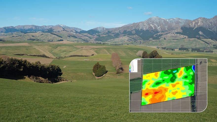
Tools, such as yield maps, crop sensor maps, Electro Magnetic (EM) and Electrical Conductivity (EC) soil maps and aerial imagery, provide information about variability in the field and where soil sampling can help interpret these variances.
Soil depth and soil texture, whether it is sand, silt or clay, change constantly across a paddock. Soil texture changes alter the soil’s ability to hold onto moisture and nutrients. For example, a sandy soil has a lower water and nutrient holding capacity than a clay soil.
By measuring the variability in sand, silt and clay across a paddock, and plotting it using GPS, we can create a map showing zones by soil texture and then sample those areas separately. This can be completed by a Soil Scientist taking soil cores and creating a soil classification report, or by using a scanning device such as an EM or EC scanner.
The scanner is towed across the paddock or area usually at 12 metre swaths. The scanner sends an electrical pulse into the soil as it drives forward. The electrical pulse then bounces back to a receiver on the scanner having arced through moisture in the soil’s pores. Then, with the aid of an algorithm, this provides a geo located reading of the soil porosity linking to the soil particle size, which indicates the soil’s texture.
A map is then created showing areas of soil texture change which then can be sampled separately, creating a fertiliser plan by zone rather than by paddock. At application time, the spreader must be capable of variably applying the fertiliser or lime (though not for nitrogen). The map can also be used to variably apply seed, slug bait, cultivations and soil moisture probes for irrigation.
These tools are beneficial as they give the ability to apply lime and plant nutrients where required, as opposed to a blanket application across an area. There are also potential environmental benefits by avoiding over fertilising areas, however the jury is still out as to the proven benefits of variably applied nitrogen.
To organise a consultation with one of our Precision Agriculture partners, contact your local PGG Wrightson Technical Field Representative.